


Geography Quizzes 15 questions per page with answers |
|||
| Geography 001 | Kampuchea is now the official name of which country? | Geography 015 | We call this place Leghorn; what do the Italians call it? |
| Geography 002 | Where in the world would you find Central Park? | Geography 016 | What is Formosa now called? |
| Geography 003 | Where is the Statue of Liberty? | Geography 017 | What is the national language of Brazil? |
| Geography 004 | Which is the world's smallest continent? | Geography 018 | What record does Mount Whitney hold? |
| Geography 005 | What does the Monument in London commemorate? | Geography 019 | What is the capital of Chile? |
| Geography 006 | How many Scilly Isles are there: 14, 40 or 140? | Geography 020 | To which country do the Azores belong? |
| Geography 007 | Which city is on the Tigris river? | Geography 021 | What happens at Oberammergau, Bavaria, every ten years? |
| Geography 008 | What is the United States' busiest airport? | Geography 022 | At which London cemetery is Karl Marx buried? |
| Geography 009 | Which Mediterranean island lies close to a smaller island called Gozo? | Geography 023 | What is the capital of Malaysia? |
| Geography 010 | What does 'Mediterranean' mean? | Geography 024 | What, exactly, was the Golden Arrow? |
| Geography 011 | Which country was awarded the George Cross in 1942? | Geography 025 | The Balearic Islands are part of which country? |
| Geography 012 | Which continent contains more than 50% of the world's population? |
Geography 026 | To which country do the Galapagos Islands belong? |
| Geography 013 | Where in London is 'Poets' Corner'? | Geography 027 | The Balearic Islands are part of which country? |
| Geography 014 | The old country of Babylonia is now called? | Geography 028 | Flags to identify |

Countries of the World
see also Student Compendium SC013_Geography
Geographical Facts
The Earth:
The Earth:
The Earth on which we live is shaped like a ball; yet it is not quite round, being a little flattened at the poles and bulging slightly at the Equator.
The Axis of the earth
The Axis of the earth is an imaginary line passing through its centre from Pole to Pole
Pole.
There are two poles—the North Pole and the South Pole.
The Equator is an imaginary line drawn round the earth, midway between the two
Diameter of the earth
The Circumference of the earth is approximately 24,800 miles (39,912 km)
The Diameter of the earth is roughly 8,000 miles (12,875 km)
The Solar System:
The Sun is fixed, and moving around the sun are a number of large spheres called planets.
The earth on which we live is one of those planets.
The Sun and the Moon are also planets.
Some of the other planets are Mercury, Venus, Earth, Mars, Jupiter, Saturn, Uranus and Neptune.and Pluto.
The Sun and all the planets around him are called the Solar System.
Pluto (minor planet designation: 134340 Pluto) is an icy dwarf planet in the Kuiper belt, a ring of bodies beyond the orbit of Neptune.
Find a Mnemonic for the planets
My Very Easy Method Just Speeds Up Names Please
When Pluto was demoted to a dwarf planet, mnemonics could no longer include the final "P"
The Sun is 93 million miles (149,668,992 km) away from the earth.
The Moon is about 240,000 miles (386,244 km) away from the earth.
Motions of the Earth:
The Earth has two motions: (a) Diurnal or Daily, and (b) Annual or Yearly.
Diurnal or Daily Motions:
The earth rotates or turns on its axis from west to east once in twenty-four hours. This is called the Rotation of the Earth.
Rotation of the earth causes Day and Night. When that side of the earth on which we live is turned towards the sun, we have day; but when it is turned away from the sun we have night.
The Annual or Yearly Motion:
The Earth turns not only on its axis. It also moves around the sun along an almost circular path called its Orbit. This journey of the earth around the sun is called the Revolution of the Earth and it takes 365 days.
Leaving out the % day our Ordinary Year consists of 365 days; but at the end of every four years the four Quarter-days are added to the ordinary year to make a Leap Year of 366 days.
Seasons:
The axis of the earth is inclined at an angle of 66^° to the plane of its orbit. As a result of this the earth is in different positions as it makes its journey round the sun. The Annual Motion of the earth, on its inclined axis therefore causes the Four Seasons of Spring, Summer, Autumn and Winter.
On March 21st the sun is overhead at the Equator. It is then Spring in the North Temperate zone.
On June 21st when the sun is overhead at the Tropic of Cancer places in the North Temperate zone have Summer.
On September 23rd the sun is back on the equator and the North Temperate zone has the season of Autumn.
On December 21st the sun is at the Tropic of Capricorn. Then the North Temperate zone has Winter.
In the South Temperate Zone the seasons are the reverse of those mentioned above at the same time of the Year.
Meteorological temperate seasons
Northern hemisphere
Southern hemisphere
Start date
End date
Winter
Summer
1 December
28 February
Spring
Autumn
1 March
31 May
Summer
Winter
1 June
31 August
Autumn
Spring
1 September
30 November
Cyclones
Cyclones and Hurricanes and Typhoons
In fact, tropical cyclones — the general name for the storms called typhoons, hurricanes or cyclones in different parts of the world — always spin counterclockwise in the Northern Hemisphere, and spin in the opposite direction in the Southern Hemisphere.
Hurricanes and Cylones are virtually the same, the ones in the North
Air rises quickly when it is heated by warm sea water.
As the air cools down again, it is pushed aside by more warm air rising below it. This cycle causes strong winds.
Tropical storms have winds faster than 73 miles an hour, (117 Kms per hour).
Hurricanes are tropical storms that form over the North Atlantic Ocean and Northeast Pacific.
Cyclones are formed over the South Pacific and Indian Ocean. Typhoons are formed over the Northwest Pacific Ocean.
A tropical cyclone is a generic term used by meteorologists to describe a rotating, organized system of clouds and thunderstorms that originates over tropical or subtropical waters and has closed, low-level circulation.
Cyclone Warnings in Australia we have four levels
in USA they have five warnings
Equinoxes
Equinoxes or equal nights (and consequently equal days) are the times when the sun is shining directly overhead at the Equator. March 21st is called the Vernal Equinox; September 23rd is called the Autumnal Equinox.
Solstices
Solstices are the times when the sun is overhead at the Tropics of Cancer and Capricorn and seems to stand for a little while before moving back in the direction of the Equator. June 21st is called the Summer Solstice, December 21st is called the Winter Solstice.
Distance: In order to enable us to calculate the distance between one place and another a number of circles are drawn round the globe.
Every circle is divided into 360 degrees (360°) and each degree is approximately 69 miles.
Lines of Latitude and Longitude enable us to measure distances on a map, or to find the position of any place on a map.
Latitude
Latitude is distance, measured in degrees, north or south of the equator.
Longitude
Longitude is distance, measured in degrees, east or west of a given Meridian.
Meridians
Meridians or mid-day lines are lines drawn on a map from the North Pole to the South Pole, and all places on any one of these lines have mid-day at the same time.
The Prime Meridian The Prime Meridian passes through Greenwich. East longitude is up to 180° East of Greenwich. West Longitude is up to 180° West of Greenwich.
The Five Chief Parallels of Latitude are:
The Equator marked 0°.
The Tropic of Cancer 23y° North of the Equator.
The Tropic of Capricorn 23L° South of the Equator.
The Arctic Circle 66t° North of the Equator.
The Antarctic 66i° South of the Equator.
Ocean currents
Ocean Currents are streams of water crossing the oceans. They follow the direction of the Prevailing Winds.
Beginning in the Atlantic Ocean, (START) the Westerly winds drive the cold Antarctic Current eastwards.
This turns northwards when it reaches the coast of Africa and is known as the Benguela Current. The South East Trade Winds take this current westwards as the South Equatorial Current. Off Cape St. Roque at the corner of Brazil this current divides into two. One branch flows south-west to become the Brazilian Current while the main current continues north-west into the Gulf of Mexico. This South Equatorial Current leaves the Gulf of Mexico and Flows north-east as the Warm Gulf Stream. It widens over the Atlantic, part flowing as the North Atlantic Drift and warming the shores of the British Isles and Northern Europe. The other part turns south at the Canaries under the influence of the North East Trade Winds to join the North Equatorial Current.
From the Arctic Ocean come the cold Arctic Current flowing along the shores of Greenland, and the cold Labrador Current. The latter meets the Warm Gulf Stream off Newfoundland. The meeting of the cold air and warm air from over these two currents causes great fogs off Newfoundland.
In the Pacific Ocean the currents are similar to those in the Atlantic but the names of some are different. The Antarctic Current joins the Peruvian Current which is continued as the South Equatorial Current. Off the East of Australia this current divides into the New South Wales Current which turns South, while the main current continues to become Japan or Kuro Siwo Current —the counterpart of the Gulf Stream. When this current turns southwards it becomes the Californian Current.
The Currents of the North Indian Ocean follow the Monsoons. Those of the South Indian Ocean follow the pattern of the Atlantic and Pacific. The most important current in this part of the Ocean is the Agulhas Current.
Ocean Currents influence Climate. Places near to a warm current have a much warmer climate than lands in the same latitude under the influence of a Cold Current.
Rain: By a process called Evaporation the heat of the sun changes much of the water of seas, rivers and lakes into water-vapour.
When this moisture laden air ascends into the colder higher regions of the atmosphere or is blown there by winds, it becomes cooled, and condensation takes place. The drops of water then unite together and fall to the earth as Rain.
The chief types of Rainfall are Convectional, Relief, Cyclonic.
Dew: During the night the earth cools more rapidly than the air above it. The layers of air nearest the earth therefore become cooled. Condensation takes place and the moisture deposited on the ground, grass and other objects is called Dew.
Rainbow : The sun's rays passing through the drops of water in the air are doubly refracted and the human eye sees the reflection in the form of a brilliant arch of prismatic colours which we call the Rainbow. A Rainbow is best seen when the rain is falling while the sun is shining.
Clouds are collections of water-vapour on the dust particles in the various layers of the atmosphere. They are usually classified as follows:
Fogs and Mist are formed when condensation of the water-vapour in the air near the earth's surface takes place upon the dust particles in the air.
" A fog is a cloud resting on the earth; a cloud is a fog floating high in the air." (Huxley.)
Snow: If the temperature in the upper layers of the atmosphere falls below freezing point then the moisture in the air is frozen into little six-sided crystals. These crystals fall to the earth as snow, but only when the temperature over the earth's surface is also near to freezing point.
Snow Line: The Level above which there is always snow.
Hail is caused by the freezing of raindrops as they pass through layers of cold air. Hence hail falls to the ground in showers of little hard pellets.
Eclipse: When the light of the sun or the moon is obscured by another body passing between it and the eye, the sun or moon is said to be in Eclipse.
The Sun is in Eclipse when the moon comes between it and the Earth.
There is an Eclipse of the moon when the earth comes between it and the sun.
Land and Sea Breezes
Land heats more rapidly and cools more quickly than the sea.
During the day, therefore, the pressure of the air over the land is lower than that over the sea. Hence breezes blow from the sea to the land.
At night the air over the sea is warmer than the air over the land so that the breeze blows from the land to the sea.
Tides: These are the regular rise and fall of the waters of the ocean. Tides are caused by the attractive force of the sun and moon acting upon the earth and on the moving waters of the ocean. There are two kinds of tides, (a) Spring Tides, which are caused by the pulling of the sun and moon together; and (b) Neap tides, which are caused when the sun and moon are at right angles and pull against each other.
There are two Spring Tides and Two Neap Tides every lunar month.
Spring tide is when the highest point of the tide is reached.
Neap tide is when the lowest point of the tide is reached.
The flow of the tide is the coming in.
The ebb of the tide is the going out.
Tides ebb and flow twice in 25 hours.
Work of the Tides: Tides alter the shape of the coast line. They form estuaries when they rush up the mouth of a narrow river;
They sometimes form bores, as in the Severn; and Capes, as when they bring material and deposit it on the continental shelf e.g. The Cape of Good Hope.
They aid shipping.
Saltness of the Sea: The water of rivers absorbs tiny particles of mineral salts from the earth which eventually reach the sea. In the course of centuries these accumulated deposits have made the sea water salt.
Continental Shelf
Continental Shelf is the name given to the land around the continents which is covered by the sea. The shelf slopes down to a depth of 100 fathoms, from which edge there is a steep drop to the bed of the ocean. Continental shelves provide excellent fishing grounds and good harbours.
The Earth's Crust is composed of rocks which are classified as either (a) Igneous, (b) Aqueous or Sedimentary or Stratified, (c) Metamorphic.
Volcanoes:
A Volcano is an opening in the earth's crust out of which steam, gases and molten rocks are hurled with terrific force.
The interior of the earth is very hot. Through cracks in the earth's surface water from the rain, rivers, seas etc., trickles down to the interior of the earth where it boils and is changed into steam. This is kept down by the pressure of the layers of the earth. At certain times the steam forces itself through a fault or a line of weakness in the earth. When this happens an eruption of a Volcano is said to have taken place.
Volcanoes may be either active, dormant or extinct.
Geysers
Geysers are hot springs from which columns of boiling water and steam gush forth at intervals. Geysers are found in regions usually associated with volcanoes. Iceland; The Yellowstone Park in Wyoming, North America; and New Zealand are famous for
bubbling geysers.
Earthquake
An Earthquake is the shaking or movement of the earth. As the interior of the earth cools it solidifies and leaves spaces between the layers of the earth. The crusts of the earth then fall or move to fit themselves on the shrinking interior. When this happens we feel the movements as Earthquakes.
Fold Mountains are caused by Earthquakes and are found along the lines of weakness of the earth.
Block Mountains are solid masses of hard resistant rocks which have been able to withstand the movements which cause folding of the earth's surface.
Valleys: When forces working inside the earth cause a block mountain to split, the " rift" thus made is known as a Rift Vallly.
When a valley runs parallel to the trend of the mountains it is Longitudinal; when it runs across it is Transverse.
A Canyon is a steep-sided gully carved out by a river flowing through a rainless region.
Isobars are lines which are drawn on a map to connect places of equal pressure.
Isotherms are lines drawn on a map to connect places having equal temperature.
Isohyets are lines drawn on a map to connect places of equal rainfall.
Contours are lines drawn on a map to connect places of equal height above sea level.
Shotts is the name of the plateau in North-West Africa between the Atlas Mountains and the Tell.
A Shott is a shallow lake which becomes dry in the hot season.
Tell: The Tell is the most important region of the French Colony of Algeria in North-West
Africa. It is a fertile coastal strip between the Algerian Plateau and the sea.
Veld: The Veld or High Veld is a rich grassland country in the eastern part of the plateau of South Africa. Most of the Transvaal, The Orange Free State and part of Cape Colony belong to it. Large flocks of sheep are reared on the Veld chiefly for Wool.
Steppes are the great temperate grasslands of Southern Russia.
Karroos: The Karroo is a natural region of South Africa between the coastlands and the
Plateau. There are two Karroos, the Little Karroo and the Great Karroo. The vegetation in the Karroos is poor and the main industries are sheep farming and ostrich rearing.
Karst is a barren region on the coast of the Adriatic Sea.
Landes are an area of Sand Dunes on the South Coast of France near Bordeaux.
Polders:
Polders are the areas of land in Holland below sea level which are enclosed by embankments and dykes. Machinery for pumping water are a feature of the Polders.
Cantons:
Cantons: The term used to describe the political divisions of Switzerland.
Water Table: The margin of the earth below which the layers of soil are saturated with water.
A Tributary is the name given to a stream which empties itself into the main river as it flows to the sea. A tributary is also known as an Affluent.
A Confluence is the place where a tributary joins the main stream.
A Flood Plain is a plain which is liable to flooding by the overflowing of a river which has become swollen by heavy rains or melting snows. A flood plain is built up of deposits of fertile alluvial soil left by the river after the floods have subsided.
A Waterfall is a steep descent or fall in the flowing of a river. Large Waterfalls are called
Cataracts; smaller ones are known as Cascades.
An Avalanche is a mass of snow and ice which breaks loose from the snow-clad mountains and slips down the mountain sides with terrific force.
A Glacier is a huge sheet of ice formed from compressed snow which glides slowly down the mountain sides or valleys.
A Moraine is the name given to the debris left after a glacier has melted.
An Iceberg is the name given to a large mass of ice floating in the sea. Icebergs are really part of a glacier which break off and fall into the sea when the glacier reaches the coast un-melted. The bulk of an iceberg is submerged, only about one-tenth being visible above the surface of the water;
Pick a country flag GUESS ITS NAME and approximate population
ENVIRONMENT - Geography
http://www.triviaplaza.com/geography-world-quizzes/
Flags of the world
Cyprus has a map on it's flag.
Nepal is the only country without a rectangular flag (it looks like two pennants glued on on top of the other).
Libya has the only flag which is all one color with no writing or decoration on it.
Australia is the richest source of mineral sands in the world. Source: Benn Skender
Iowa is the only state bordered on both east and west entirely by rivers. (Mississippi on the east, Missouri and Big Sioux on the west.)
I, Q, and X are the only letters that don't start a city that ends in -ville in the state of Ohio. i.e. Brownsville, Zanesville, etc.
The Atlantic Ocean is saltier than the Pacific Ocean. Source: "Uncle John's Bathroom Reader"
In 1771 the kingdom of Poland was larger in area than any other European country except Russia, and had a bigger population of any other European country except France. But within 25 years it had vanished from the map.
In 1772, Russia, Prussia and Austria between them annexed about one-fifth of Poland. Twenty years later Russia took over half of what remained, and all three powers shared in the final carve-up in 1795. It was not until 1918, in the aftermath of the First World War, that an independent Poland surfaced again, to be overrun yet again in 1939. Source: "Reader's Digest Book of Facts"The bridge of Sighs, most famous of the 400 bridges in Venice, Italy, connects the Dodge's palace to the old state prisons and the place of execution. It was built in 1600 and is believed to have got its name from the sigh of the condemned. Source: "Reader's Digest Book of Facts"
32% of all land in the U.S. is owned by the federal government. Source: "Uncle John's Bathroom Reader"
There are, surprisingly, very few nations in the world named after an actual person. Among those are Bolvis, for Simon Bolivar; Columbia, for Christopher Columbus; Nicaragua, for Chief Nicarao, Liechtenstein, for Johann von Liechtenstein; Saudi Arabia, for King Saud; and the Philippines, named after King Philip. The United States of America got its name from Amerigo Vespucci. Source: "Knowledge in a Nutshell"
More than 25 percent of the world's forests are in Siberia. Source: "2201 Fascinating Facts"
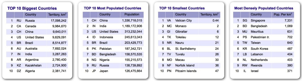
There are two independent nations, both in Europe, that are smaller than Central Park in New York City. They are Vatican City and Monaco. Each is less than one square mile. The next three smallest countries are Bauru, eight square miles, in the western Pacific Ocean; Tuvalu, ten square miles, the Southwest Pacific; and San Marino, 24 square miles, in Europe. Source: "Knowledge in a Nutshell"
The Philippine flag is displayed with its blue field on top in times of peace. When war is declared, it is flown with the red field on top. Source: "Selwyn Clyde Alojipan"
The capital of Portugal was moved to Rio de Jeneiro, Brazil (at the time a colony of Portugal) from 1807 until 1821 while Portugal was fighting france in the Napoleonic Wars. Source: "Knowledge in a Nutshell"
If the world's total land area was divided equally among the world's people, each person would get 8.5 acres.
Maine is the toothpick capital of the world.
Seoul, the South Korean capital, just means "the capital" in the Korean language.
Libya is the only country in the world with a solid, single-colored flag -- it's green.
Panama hats come from Ecuador not Panama.
Ogdensburg, New York is the only city in the United States situated on the St. Lawrence River.
St. Paul, Minnesota was originally called Pigs Eye after a man who ran a saloon there.
The Boston University Bridge (on Commonwealth Avenue, Boston, Massachusetts) is the only place in the world where a boat can sail under a train driving under a car driving under an airplane. Source: "Random Trivia" fact contributed by Jim Cobb
Rhode Island is the smallest state with the longest name. The official name, used on all state documents, is Rhode Island and Providence Plantations.
The state of Maryland has no natural lakes.
Seattle, Washington, like Rome, was built on seven hills.
Kitsap County, Washington, was originally called Slaughter County, and the first hotel there was called the Slaughter House.
The coast line around Lake Sakawea in North Dakota is longer than the California coastline along the Pacific Ocean
Brooklyn is the Dutch name for "broken valley"
There are four states where the first letter of the capital city is the same letter as the first letter of the state: Dover, Delaware; Honolulu, Hawaii; Indianapolis, Indiana; and Oklahoma City, Oklahoma.
Lake Nicaragua boasts the only fresh-water sharks in the entire world.
The flag of the Philippines is the only national flag that is flown differently during times of peace or war. A portion of the flag is blue, while the other is red. The blue portion is flown on top in time of peace and the red portion is flown in wartime.
The only city in the United States to celebrate Halloween on the October 30 instead of October 31 is Carson City, Nevada. October 31 is Nevada Day and is celebrated with a large street party.
Eleven square miles of southwest Kentucky (Fulton County) is cut off from the rest of the state by the Mississippi River. If you wish to travel from this cut off section to the rest of the state or vice-versa, you must first cross a bordering state.
http://www.triviachamp.com/Geography-Trivia.php
https://triviachamp.com/Geography-Trivia.php
Geography Quiz 1 (Answers below)
1 Kampuchea is now the official name of which country?
2 Which important American city stands on the Potomac river?
3 Where and what is the Serpentine?
4 Where is Ruritania?
5 The original building for one of the world’s largest museums was called Montague House, London. What is it called now?
6 What is the commonest name for a pub in Britain?
7 What, in earlier times, was the main industry of Paternoster Row, London?
8 Which are the Low Countries?
9 If you ‘crossed the Rubicon’ where would you be?
10 Where are the Cheviot Hills? Southern or Northern England?
11 Which is the largest railway station in the United Kingdom?
12 Where is the River Kwai (made famous by the book about its bridge)?
13 Where in the world do they speak Tamil?
14 What is the capital of Algeria?
15 There is a ‘Tin Pan Alley’ in both London and New York. What is it?
Countries of the world
Australian Trivia
1. We are one of the few countries that eats their national animal.
2. The Emu and the Kangaroo are on our crest because neither animal can walk backwards.
3. Per capita, we read more newspapers than any other nation.
4. The ‘dingo fence’ is the longest fence in the world (5,530km). It is about twice as long as the Great Wall of China.
5. The largest Greek population outside of Athens is found in Melbourne.
6. 750,000 camels roam our deserts, the largest number of purebred camels in the world.
7. Adelaide’s Botanic Gardens are home to the oldest glasshouses in the Southern Hemisphere.
8. The Australian Alps receive more snow than Switzerland.
9. Glenelg (in Adelaide), Tumut (in NSW) and Parap (in Darwin) are all palindromes.
10. We have 20% of the world’s poker machines, but only .33% of the world’s population.
11. Perth is the only city in the world which can have aircraft land in its CBD.
12. We are the only continent without an active volcano.
13. The Seekers were named joint Australians of the Year in 1967.
14. Crocodile Dundee is the highest grossing Australian film to date.
15. It is illegal to walk on the right hand side of the footpath.
16. If all of the shells on the roof of the Sydney Opera House were combined, they would create a perfect sphere.
17. Fraser Island is the world’s largest sand island.
18. Cathy Freeman is the only person to have been awarded both Young Australian of the Year and Australian of the Year.
19. We hold the world record for the most number of Christmas lights on a house. Over half a million lights were placed on a Canberra house 2005 Christmas.
20. The average Australian will consume 165,000 eggs in his or her lifetime.
21. No native Australian animals have hooves.
22. When the English settlers first saw a platypus they thought Australians were trolling them by sewing a duck bill on a rat.
23. In 1838 it was declared illegal to swim at public beaches during the day. This law remained in force until 1902.
24. Kalgoorlie in Western Australia is the our largest electorate, spanning 2,225,278 square kilometers.
25. Sydney Symphony Orchestra’s performance at the 2000 Olympics was pre-recorded by the Melbourne Symphony Orchestra.
26. The wine cask is an Australian invention as is the hoist washing line and UTE vehicles.


For those students that presented work on English we gathered a lot of useful reference information that became a STUDENT's COMPENDIUM here are some samples of student work
Please note there are some excellent links to assist with these pages
see at the end for the links for further information.
Abbreviations
Acronyms


![]()

Tutorials  Naplan Training Courses Resources Quizzes

![]()
 |
 |
 |
 |
 |
|
 |
|||||
 |
 |
 |
 |
 |
 |
|
Back to Top

Email Peter Faulks
Applied Information Technology * AITStage1 * AITStage2 * AITStage3 * Cert II Business * Cert II Information Technology * Multimedia
Subjects * Art * Computing * English * Geography * Hass * History * Mathematics
Miscellaneous * Acronyms * Accreditation * ICT_Homework * Naplan * Lessons * Quizzes * Relief Lessons * Proverbs * Sayings * Student Compendium
Exams & Tests * Student Survival Kit * Web quests * Worksheets * Home Page * Peters Site * Soccer
Answers to Quiz 1
1. Cambodia. 2. Washington. 3. It’s a lake in Hyde Park, London. 4. It doesn’t exist. It’s fictional! 5. The British Museum. 6. The Red Lion. 7. Book selling and publishing. 8. Belgium, the Netherlands and Luxembourg. 9. Italy. 10. Northern England. 11. Clapham Junction. 12. In Thailand. 13. Southern India and Sri Lanka. 14. Algiers. 15. The area given over to publishers and writers of popular music.

Page last updated 2nd January 2020